A-10 ATTACK! v1.5
Arizona VFR Sectional Read Me
![]()
![]()
(You will probably need to expand your browser window,
and set your color depth to 16 bit.)
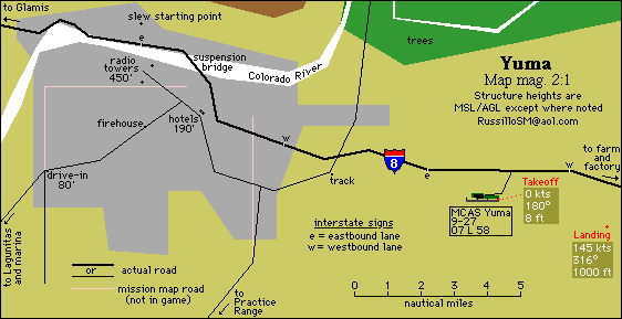
Click here for the Yuma map (8k)
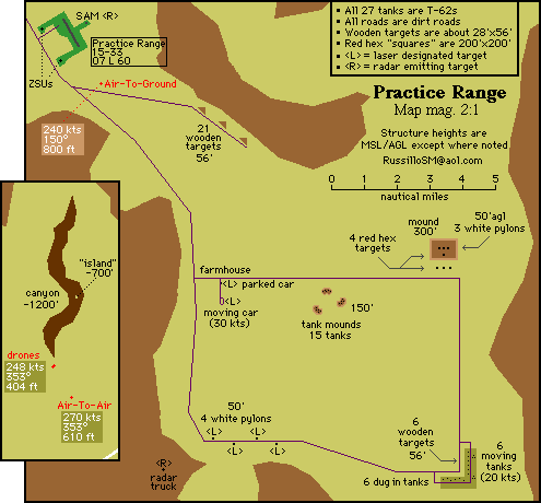
Click here for the Practice Range map (11k)
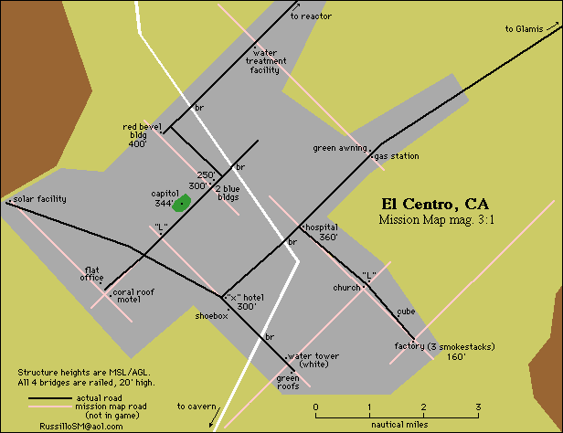
Click here for the El Centro map (12k)
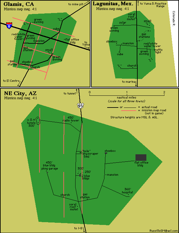
Click here for the three smaller towns map (17k)
Read Me contents...
General info | Perspective | Game Trivia | More On Slewing | Structures | Cavern | AIRPORT INFO
The nautical mile "bracket" scale on the map itself and the "onscreen scale" will remain accurate regardless of print scaling.
The separate town and city maps print at normal 100% scale.
For purposes of simplification (and, frankly, so that images are easier for me to work with) these maps are based upon the mission maps as they appear with the "Map Textures" preference deselected. In Attack there is a clear differentiation between sea level (tan) and mountainous terrain (brown), and I wanted a black & white printed version of the map to be able to reflect that, especially since the shapes of the mountainous areas are ideal visual references. (If your printer cartridge can spare it, I strongly recommend printing these at "normal" quality. Some of the lighter features are difficult to see when printed in "draft" quality.)
All the info in this map and Read Me were directly observed in the MAC VERSION OF THE GAME ONLY and measured in as precise a way as I could muster: the runway lengths may not be completely accurate, though I'm sure they're at least close. Probably within 10'. Also imperfect will be the elevations of the mountain peaks (but again, they should be close, probably within 50'.)
The two are not necessarily mutually exclusive, but regardless what they were intended to be, they're being used as target ranges by me! But still, as you fly over hospitals and skyscrapers and mansions, it's hard not to also imagine cars and everything else in a typical city. (But then, the typical city doesn't have one building per mile with sand dunes in between...)
Instances wherein I could find no corresponding 'real life' name for a town or city that appears in the game...well, I winged it. Unlike the Germany theatre where the cities and towns closely correspond to real German towns, there is just a passing similarity between the "municipalities" in the Arizona theatre and those of the real region. Any correlation on my part is quite forced, and will be evident to anyone who might bother to compare this map to a real map of the region. Most notably:
El Centro isn't sitting on the Mexican border. I "surveyed" the national borders based on a point of reference consistent with real life, the I-8 bridge over the Colorado River in Yuma. (The Arizona-California state line is the Colorado River itself.)
I-8 runs south of the Salton Sea, through El Centro.
In real life one runway at MCAS Yuma/Yuma Intl., 03L-21R, is 13299' long making it one of the longer runways in North America. [13R-31L at JFK is the only civilian runway I could find longer, at 14572'. Naturally, the Shuttle landing strips at Kennedy and White Sands are longer than both of these (15000x300 each), and a few of the many at Edwards are considerably longer yet: 04-22 is 26500x300, 15-23 is 31200x300, and 17-35 is 39200x300.] When I was a kid we lived in Yuma, right under the approach path to RWY 17, maybe a half-mile from the end of the runway. Swimming in our back yard, I remember being able to see the reflection of our pool in the bottom of more than one shiny-bellied airplane.
A rose by any other name...
When slewing, the smallest increment of movement you can make--the smallest "click" of keypad 1, 2, 4, 6, 7, 8 followed immediately by keypad 5--is about 15" in any direction. [This does not mean that you cannot move up (or in any other direction) less than 15". Raise the "nose" slightly above the horizon, click forward, and in addition to moving predominantly forward, you will move in vertical increments much smaller than 15".]
Most of the target structures labeled on the city maps are self-explanatory. A few could use more explanation.
Perhaps the most fascinating easter egg in all three A-10 theaters is the cavern, 40 nm down the river from El Centro (although that commander's compound in Cuba is pretty cool, as is the underground runway in Europe). Not much to the cavern--a lake, a waterfall and an island--but it is massive. It's internal height is about 8300', the top of the cavern being about -700' MSL. As you enter the cavern, the far wall is about 3.1 nm away, and the two "walls" to your left and right are 3.3 nm apart: the cave is slightly wider than it is long. ("Walls" is a term used loosely...the cave has no regular shape, as you can observe by slewing around it.)
Using CCIP you can easily determine that the bottom of the cave is an even -9000' MSL, while the island in the middle of the lake is 1000' high. The island is roughly 2200' across, and provides the light for the cave. (Only kidding, but if you advance the time with the 'n' key, you'll see that the island does retain it's orange luminescence during the night.)
The waterfall is 6300' above the cavern floor, as is, obviously, the bottom of the entrance tunnel. The vertical wall portion of the waterfall is 3900'.
The tunnel into the cave is 267' wide (that's over 4.5 times the wingspan of your Hog, you should have little difficulty flying through it), 6990' long, descends at an angle of 33°, and is on a heading of 217°. When egressing the cavern the tunnel's heading is 37°.
For a surreal sight, slew down directly below the cavern--way down--then look up at it vertically. Now pop 'n' a few times to bring the stars out...
BOTH RUNWAYS ARE AT SEA LEVEL. When parked on healthy landing gear the altimeter will read 07' MSL
BOTH RUNWAYS HAVE VISUAL APPROACH SLOPE INDICATOR (VASI) as well as RUNWAY LIGHTING, AND A MODIFIED MEDIUM INTENSITY APPROACH LIGHTING SYSTEM (MALSR.) All VASI is V2L (2 boxes on the left) except for RWY 33 at the Practice Range, which is V2R.
Altitudes given here are MSL, read from the chit leader while parked on the runway. Subtract 7' for true altitudes.
Both airfields have a VOR transmitter within a few hundred feet of the runway. They are the white pylons sticking up out of a red and white checkered box. 30' square, 40' tall....good for target practice. (While true TACAN functions much like VOR/DME, destroying the VOR beacons has no effect on TACAN waypoints.)
RWY 15-33: 6000x100
RWY 09-27: 5850x100
As with the other maps, these folks' work was enormously helpful.
...Tom "Howdy" Curtis for mucho support, and for his two A-10 Attack & Cuba help files, Stupid Hawg Tricks and Cuba Tactics. Indispensable for the virtual Hawg Driver.
...Petteri Sulonen for his excellent A-10 Attack! help file, A-10 Attack FAQ.
...Eugene Pak, et. al. for the comprehensive FAQ on the real A-10, A-10 FAQ (rev 1.2). Special thanks also to Eugene for continued support.
...as always, thanks to the folks at PARSOFT INTERACTIVE especially, for CREATING THESE TERRIFIC SIMULATORS...hard to believe this program is two years old.
...and especially, Vic Russillo, Lt. Col. USMC (Ret.), former F-4 Phantom RIO, all around good guy, and my dad.
Well, after doing three of these things, I think I'm ready to just play the game for a change!
Hope you like it. Let me know what you think!
Steve Russillo
russillosm@gmail.com
May 1, 1997
![]()
Back to the top | Back to the A-10 Page
Cuba Map/Trivia | Europe Map/Trivia